|
|
ForensicArtist
Applying technology to rebuilding Iraq's infrastructure has
required intense collaborative planning and efforts.
The Role of Surveyors in Operation Iraqi Freedom
Surveying Goes Underground
GPS Modernization
Uncovering an Extraordinary World - Archaeologists in Sudan excavate with laser precision.
Rebuilding Afghanistan
Surveyors shine in shuttle recovery
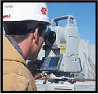
Articles listed below are examples of diverse and successful careers of Professional Land Surveyors:
Crime Scene Investigation has replaced old-fashioned hand-mapping of crime scenes with automated data collection....
This article appeared in the Fall 2004 issue of The American Surveyor. (This is a large pdf file complete with images.)
One Rhode Island firm is proud to be part of the good news coming out of Iraq that is sorely missing from today's mainstream media outlets. In doing so they are
also helping to provide training, new jobs, and a better way of life for many of the city's seven million residents.
This article appeared in the June 2005 issue of The American Surveyor. (This is a large pdf file complete with images.)
Topographic surveyors from the 320th Engineering Company pave the way for fixed-wing aircraft operations throughout northern Iraq.
This article appeared in the April 2004 issue of Professional Surveyor.
Surveying, Caveman Style - The process of mapping a cave usually involves a team of three to four explorers.
This article appeared in the February 2004 issue of Professional Surveyor.
The GPS Constellation - Developed in 1973 by and for the United States Department of Defense (DOD), the GPS system...
This article appeared in the February 2004 issue of Professional Surveyor.
As lead archaeologist, I had the rare opportunity to make some exciting discoveries...
This article appeared in the November 2003 issue of Point of Beginning (POB) Magazine.
Humanitarian efforts by U.S. Army and Leica assist a devastated country.
This is a 3.42Mb pdf of this 13 page article complete with color images.
This article appeared in the June 2003 issue of Professional Surveyor Magazine
Click here for a text only version of this story.
Click here for pictures that were not in the article.
When the Columbia disintegrated on February 1, debris rained down on 40 counties in TX and LA, scattering over hundreds of miles...
And then there were Surveyors with their GPS equipment, and GIS managers with topographic maps, and geography professors and students....
This article appeared in the March/April 2003 issue of the ACSM Bulletin
